The speed at which we’ve been able to go from just being able to create 3D models by meticulously collecting data to what we’re able to do today. These same models can be created with just a few images, or even video, as we’ll get to in this post. It’s nothing short of amazing the things we’re able to do to maximize our ability to conceptualize our world in three dimensions, utilizing different technologies in different places for different use cases. Today’s articles from friends around the industry highlight just this.
First up, we have a look at one of the innovations unlocked by 3Dsurvey, who creates software for processing photogrammetry for surveyors. Specifically, this article outlines how their videogrammetry tool works and how it can be used by professionals in their workflows. Next up, we head to outer space for a project sponsored by the International Space Station to test new 3D mapping technology. Finally, we read about two of the industry’s favorite buzzwords at the moment – AI and digital twins. Find the full articles below.
Exploring the potential of videogrammetry
Matija Zupan & Amy Nicol | GIM International
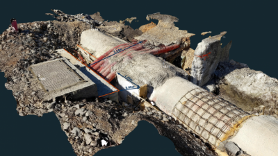
As noted above, 3Dsurvey’s software provides a number of tools for surveyors who are creating models from photogrammetric workflows, particularly (but not limited to) projects that utilize UAVs. One of the most intriguing tools available in the software is what they call videogrammetry. Similar to other 3D model creation tools we’ve seen like NeRFs and Gaussian Splats, videogrammetry takes a short video and derives individual frames to use as a basis for a 3D model. The result is an accurate model with a significantly simpler workflow. This article, the authors of which are from the 3Dsurvey team, outline how the tool works and how it can be applied in surveying projects.

Testing Novel 3D Mapping Technology to Transform Space Exploration and Benefit Industries on Earth
ISS National Laboratory
Next up we have some news from the International Space Station (ISS) National Laboratory, who announced that they will be using their Multi-Resolution Scanner to test out a “novel 3D mapping technology that can produce detailed maps of remote environments.” The project is a collaboration between Boeing and Australian government agency CSIRO, and is designed to “rapidly create 3D maps of various environments in unprecedented detail, like the space station or even a lava tube on the Moon or Mars.” This project is still very much in the early stages, and one can expect it to advance to different environments given success.”

AI twins and the digital revolution
Mike Robuck | Mobile World Live
Finally, we look at arguably the two biggest buzzwords across industry right now in digital twins and AI. As we’ve discussed before, these two technologies are not at all opposed, and in fact work ideally as a pair. This article talks about just that, specifically how the two can be used in concert specifically in the telecom industry. The article focuses on the ways network planning and optimization can benefit, as well as the ways that AI and digital twins can smoothly prepare the industry and public for the eventual implementation of 6G.